[New Chitose Airport IN → Wakkanai Airport OUT / 1 Night 2 Days] Via Sweet Road to Wakkanai While Watching the Sunset at Ogon Misaki! A Unique Northern Hokkaido Trip
![[New Chitose Airport IN → Wakkanai Airport OUT / 1 Night 2 Days] Via Sweet Road to Wakkanai While Watching the Sunset at Ogon Misaki! A Unique Northern Hokkaido Trip](/lsc/upfile/course/0000/0090/90_1_l.jpg)
- Spring
- Summer
- Autumn
- Winter
- Days required
- 2 days and 1 nights
- Main methods of transportation
- Car
Our 2-day, 1-night trip is the perfect way to see a side of the region you never knew existed. Starting from New Chitose Airport, you'll drive north towards Wakkanai, exploring picturesque landscapes, breathtaking sunsets, and local gourmet foods. With plenty of hot springs along the way, this journey is all about relaxation and discovery. Pack your bags and get ready for an unforgettable off-the-beaten-path adventure in Northern Hokkaido.
- * The spots and experience menus introduced in the course are subject to change. Please check the official website for the latest information.
- * Please note that the text shown on this page includes machine translations.
New Chitose Airport
The Gateway to Hokkaido
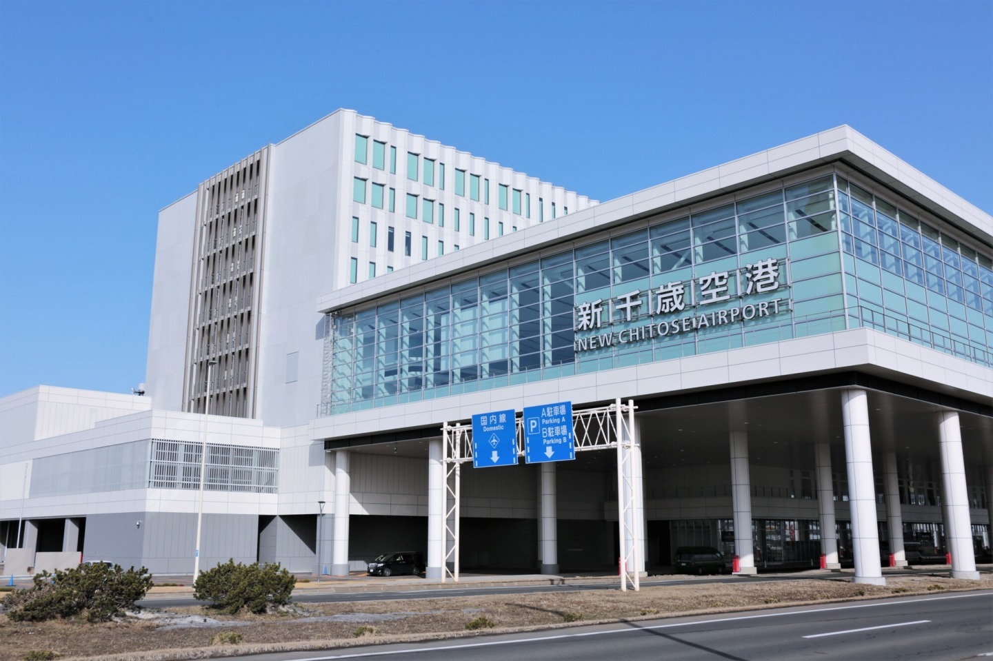
When you arrive at New Chitose Airport, your Hokkaido journey truly begins. Renting a car here is the perfect way to start exploring, giving you the freedom to head north along the Hokkaido Expwy toward Sunagawa. In about 90 minutes, you’ll reach one of the sweetest destinations in central Hokkaido.
Sunagawa Sweet Road
A Delicious Journey Through the “Town of Sweets”


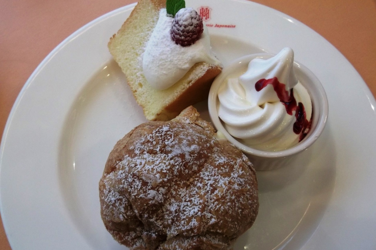
Stretching about 5 km along National Route 12, Sunagawa Sweet Road is lined with more than 20 delightful confectionery shops and cozy cafés. This area of Sorachi once thrived as a coal mining region, and sweet treats here have long been a source of comfort and energy for the hardworking community. Today, visitors can experience the same warmth and joy through every bite.
From long-established wagashi (traditional Japanese sweets) shops to elegant patisseries and welcoming cafés, each store along this road has its own unique character. Driving from one to another feels like a treasure hunt for your perfect dessert. Surrounded by the aroma of freshly baked pastries and hand-crafted sweets, you’ll find yourself creating travel memories as heartwarming as the flavors themselves.
A drive along Sunagawa Sweet Road is more than just a tasting tour—it’s an invitation to slow down, indulge, and discover the true sweetness of Hokkaido.
- Address
- 北海道砂川市
Cape Ogon
A Golden Sunset Over the Sea of Japan
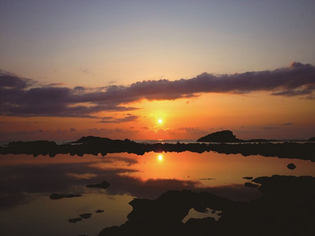
Cape Ogon in Rumoi is a highlight of the Ororon Line, a scenic coastal drive along the Sea of Japan. Chosen as one of the “Top 100 Sunsets in Japan,” and one of only 5 in Hokkaido, this cape offers a truly unforgettable view of twilight.
Once used as a lookout for herring fishing, Cape Ogon earned its name from the golden glow of massive herring schools illuminated by the setting sun. The sight of countless fish sparkling like liquid gold as they approached the shore became legendary and gave the cape its enduring name.
Today, the cape is celebrated for sunsets often called the “most beautiful in Japan.” As the sun slowly sinks below the horizon, the sea and sky are filled with brilliant shades of orange and red. The warm glow spreads across the landscape, creating a powerful and moving scene.
- Address
- 北海道留萌市大町2丁目
Haboro Onsen Sunset Plaza
Your Oasis on the Orolon Line
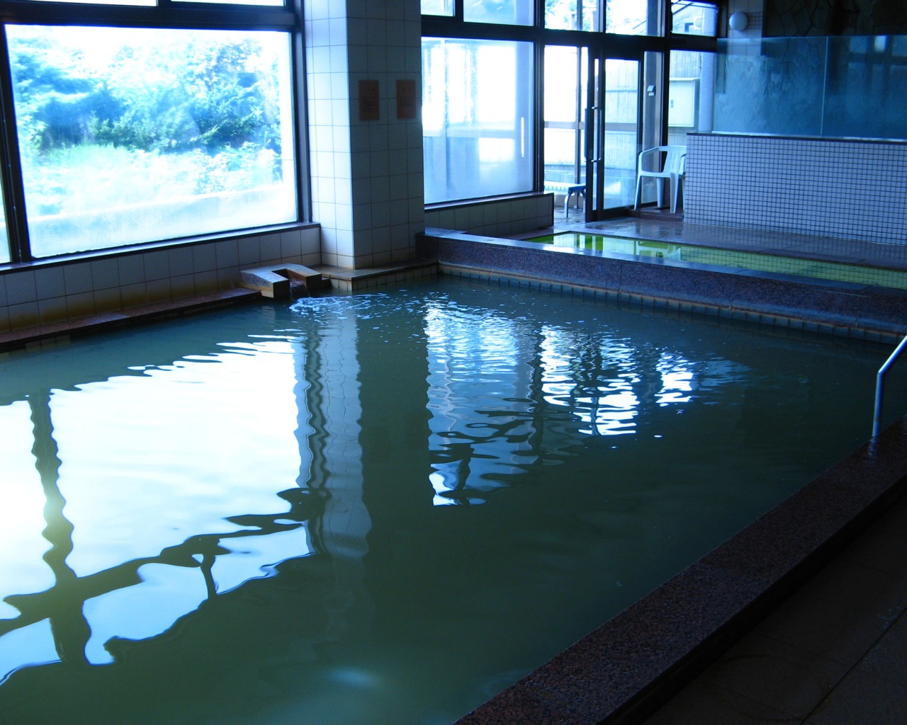
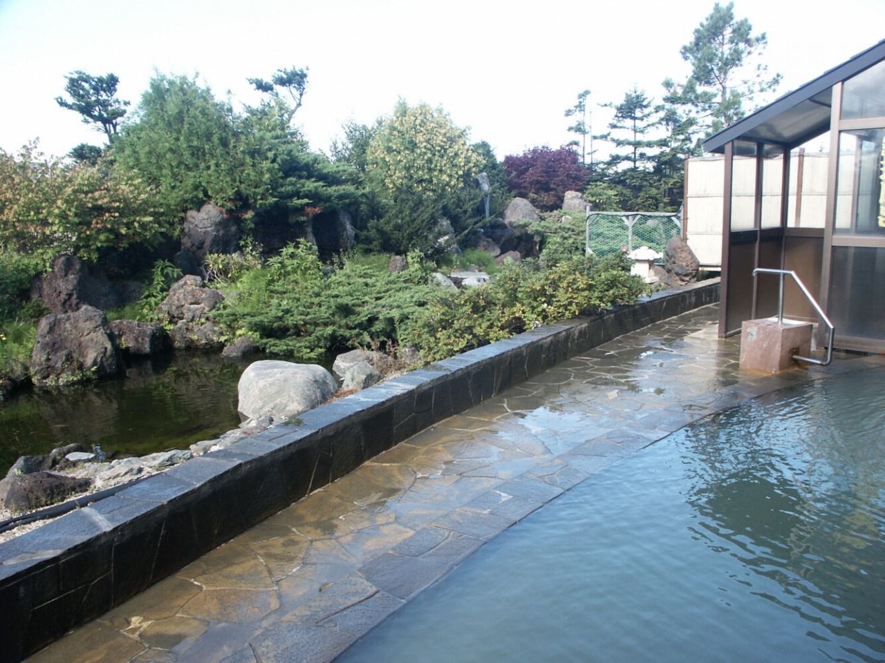
Along the Ororon Line facing the Sea of Japan, Haboro Onsen Sunset Plaza is a hot spring inn beloved by locals. Connected to Michi-no-Eki Hotto♡Haboro and close to the ferry port for Teuri and Yagishiri Islands, it is an ideal base for sightseeing.
The inn is best known for its breathtaking sunsets. From the spacious public bath and the Japanese garden–style open-air bath, you can relax while watching the glowing sky and the silhouettes of the islands on the horizon. The mineral-rich reddish-brown salt spring is praised for warming the body, and guests can also enjoy a reclining bath and sauna.
Dinner features Haboro’s famous sweet shrimp, with the town boasting Japan’s largest catch. Fresh seafood and seasonal dishes make the experience even more memorable.
With spectacular sunsets, soothing hot springs, and local cuisine, Haboro Onsen Sunset Plaza is a true seaside retreat that refreshes both body and spirit.
- Address
- 北海道苫前郡羽幌町北3条1丁目29
- Telephone Number
- 0164-62-3800
Toyosaki Konpira Shrine
A vermilion torii gate rising from the surf, framed by the setting sun
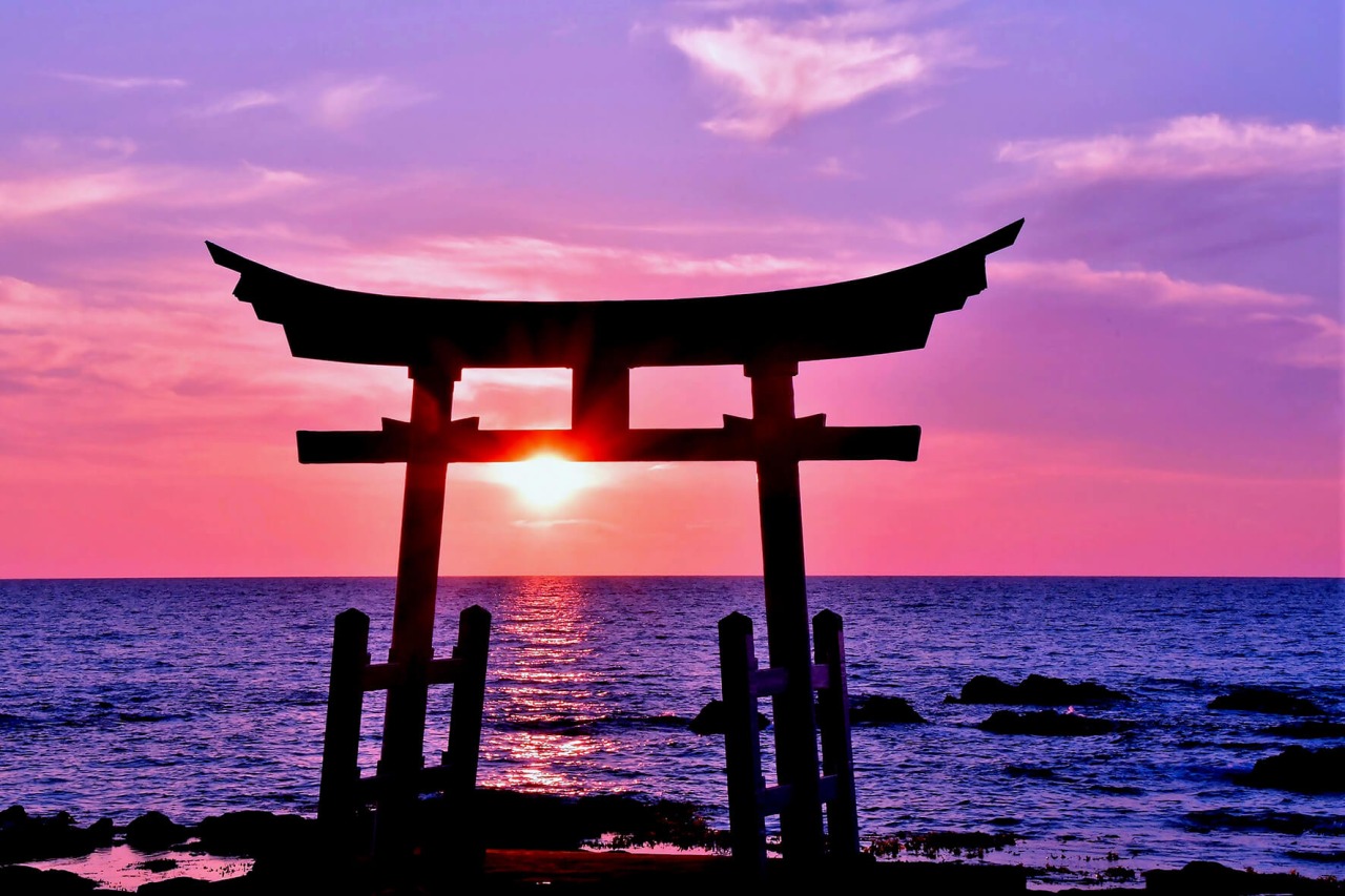
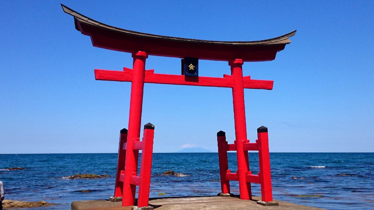
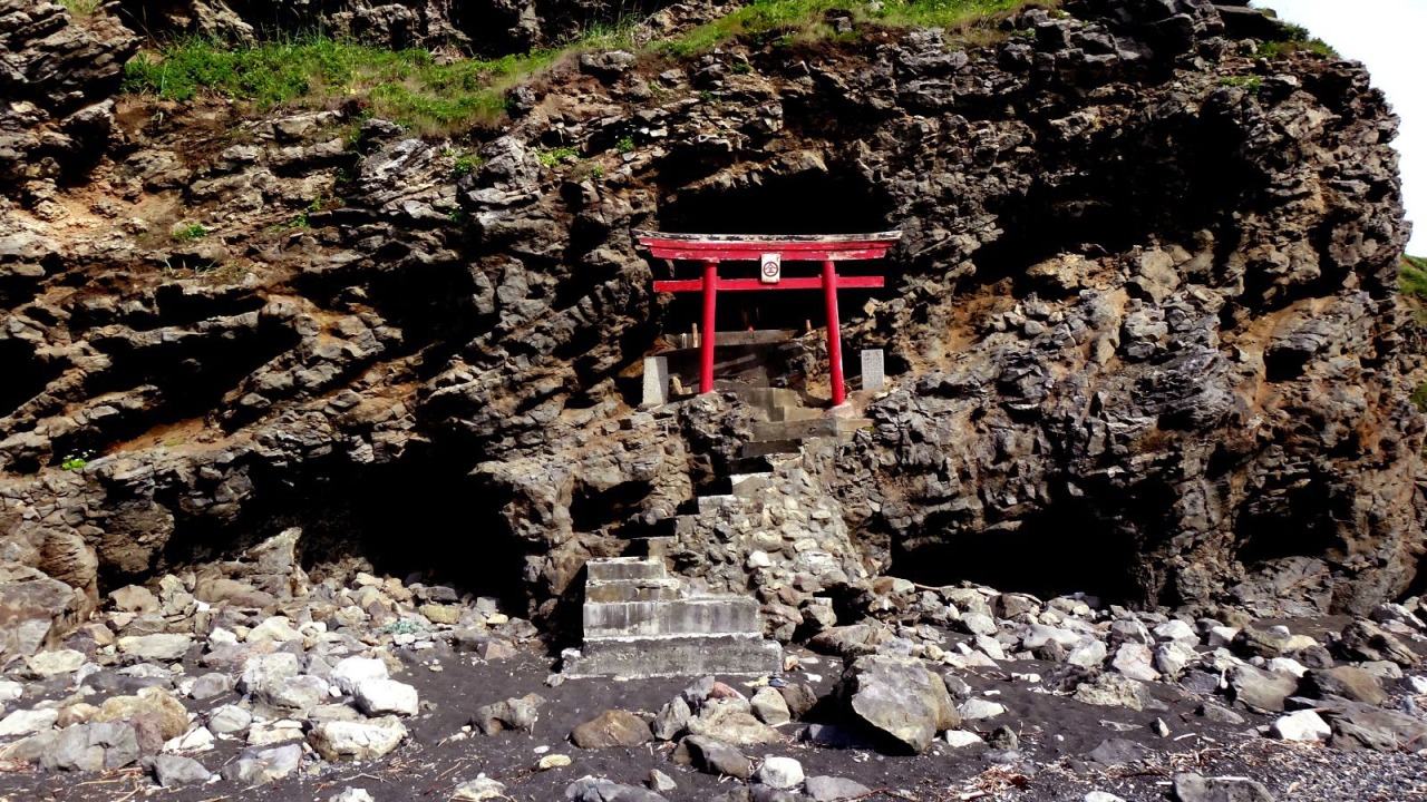
Experience a mystical moment in Shosanbetsu Village, where a vermilion torii gate meets the horizon, glowing in the warm hues of a sunset over the Sea of Japan.
Located at the foot of Cape Konpira, Konpira Shrine has long been revered by the local community as a guardian of maritime safety. Its origins date back to a fisherman who enshrined a sacred Konpira talisman that had washed ashore on this rugged cape. The shrine’s most striking feature is the vivid vermilion torii gate standing in the crashing waves of the Sea of Japan. Its appearance shifts with the tide—floating gracefully at high tide, and standing firmly on the shore as the water recedes. The steady rhythm of waves against the rocks creates a tranquil, almost meditative atmosphere.
The most enchanting time to visit is at dusk, when the sky is painted in deep, fiery shades of orange. For a brief moment, the setting sun aligns perfectly within the torii gate, creating a view that feels almost dreamlike. As you stroll through the grounds, the cool sea breeze and the scent of the ocean deepen the sense of connection with nature. From the nearby Konpira Cape Lighthouse, you can take in a sweeping coastal view, where the brilliant vermilion gate stands in vivid contrast to the deep blue sea—a sight you won’t soon forget.
- Address
- 苫前郡初山別村豊岬
- Telephone Number
- 0164-67-2211
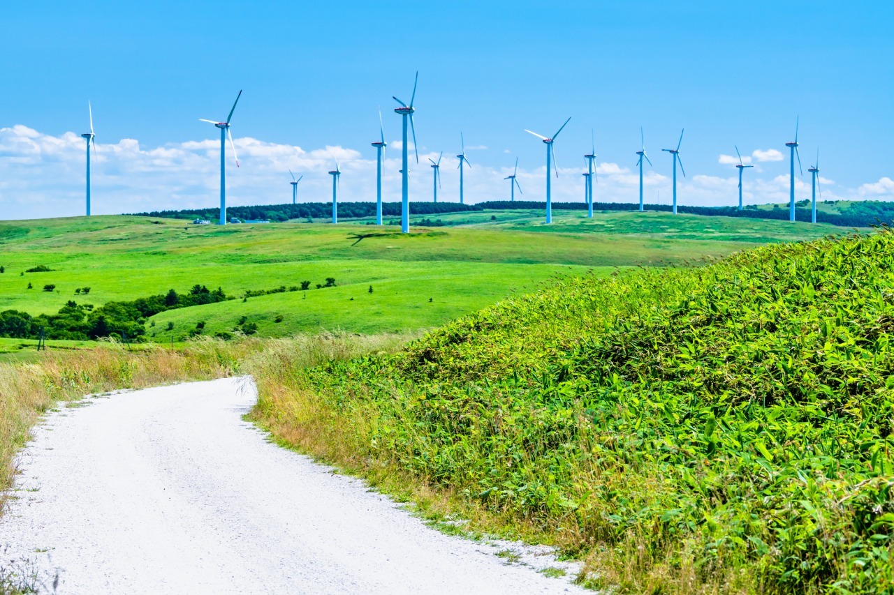
Otonrui Wind Farm
A Striking Landscape of Endless Turbines
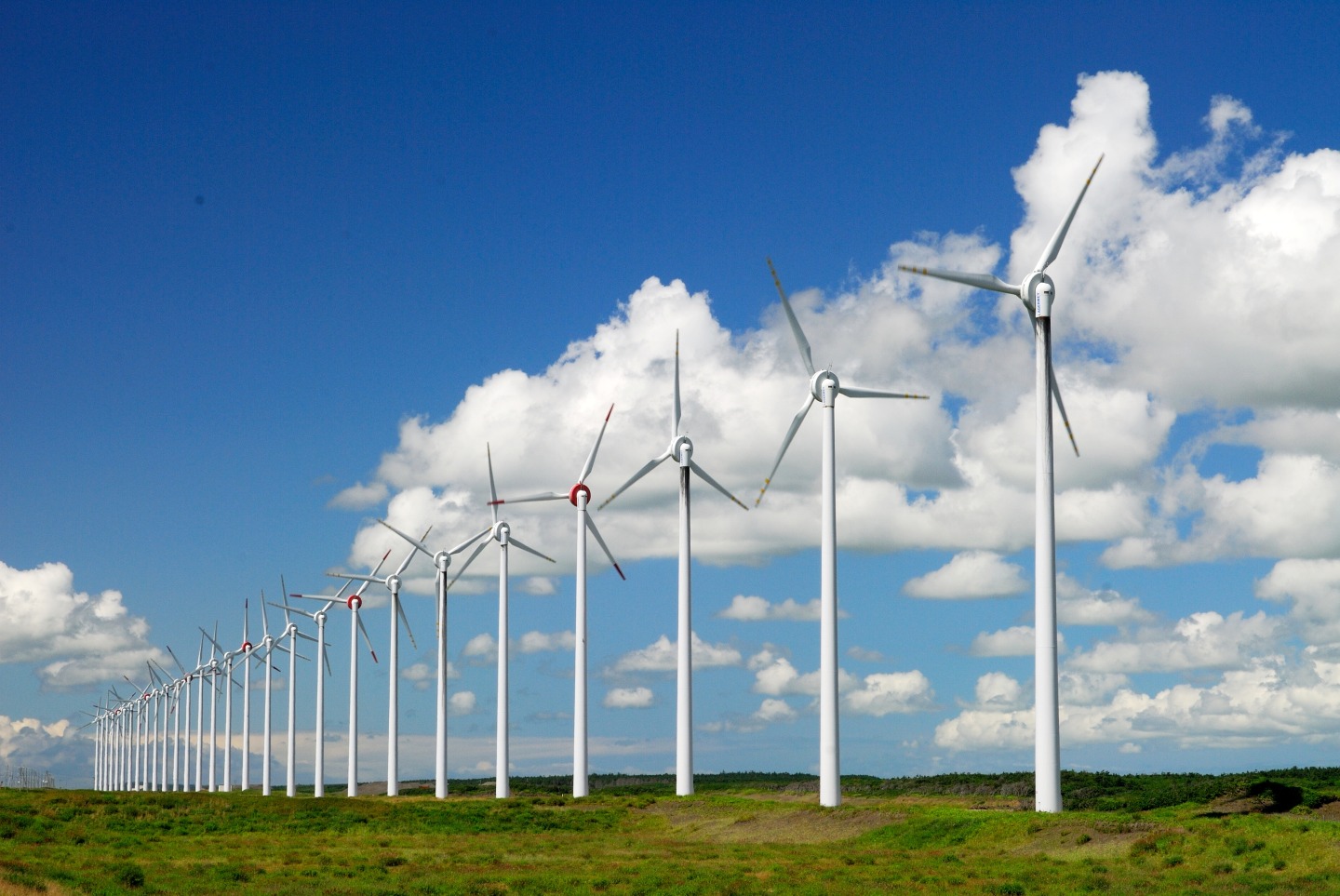
Along the Ororon Line in northern Hokkaido stretches the Otonrui Wind Farm, where 28 massive wind turbines, each towering about 99 meters high, stand in a straight line for 3.1 km. The sheer scale of these turbines set against vast green pastures creates a breathtaking sight that feels more like a scene from abroad than Japan.
On clear days, the majestic silhouette of Mt. Rishiri can be seen across the sea, adding another layer of beauty to the view. The contrast between Hokkaido’s expansive natural scenery and the modern turbines turning powerfully in the wind is both impressive and unforgettable.
A visit to Otonrui Wind Farm offers a rare chance to experience one of Hokkaido’s most unique landscapes, blending nature and technology in harmony.
- Address
- 北海道天塩郡幌延町
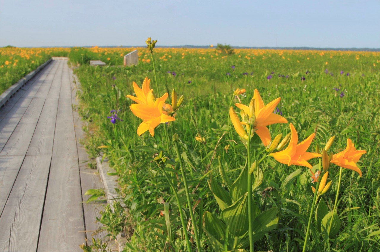
Sarobetsu Wetland・Sarobetsu Wetland Center
Walk above a landscape shaped over 6,000 years
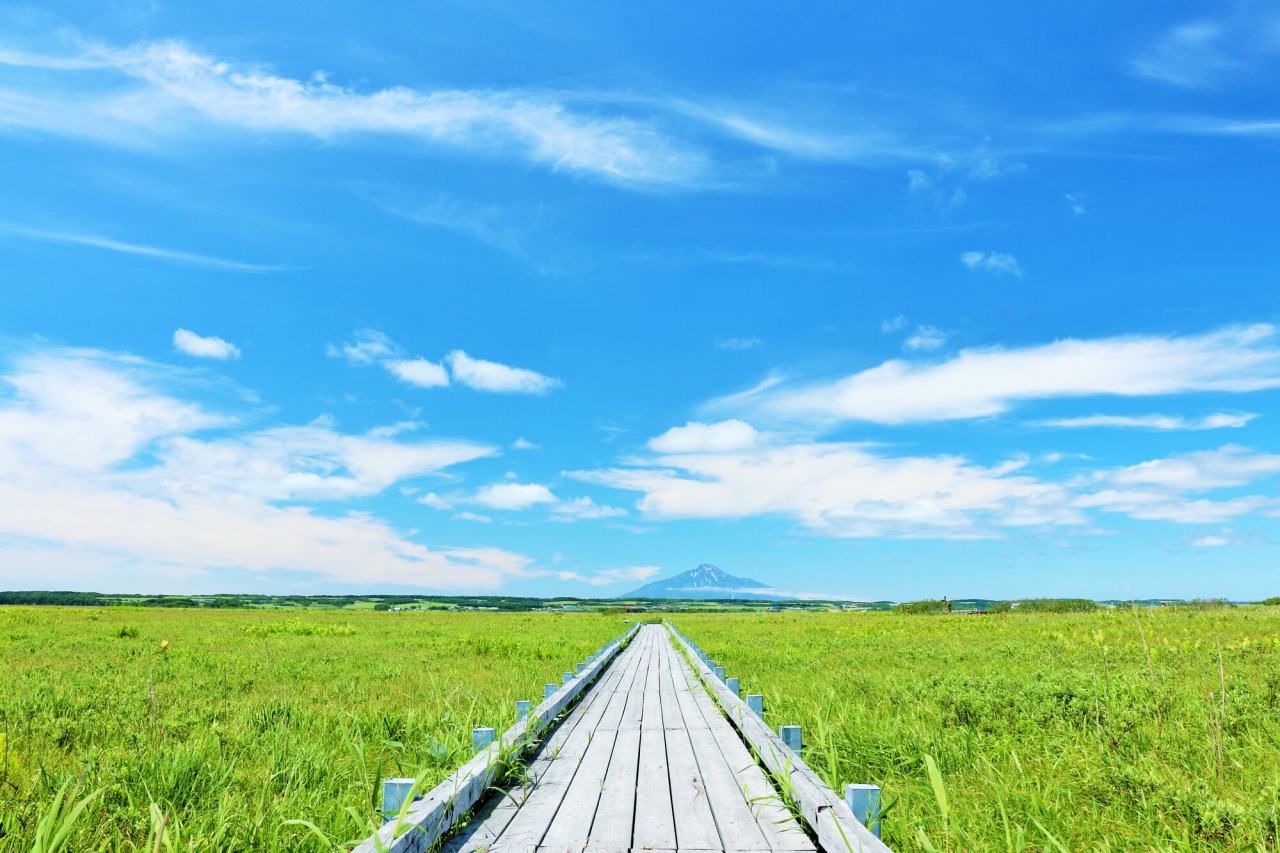
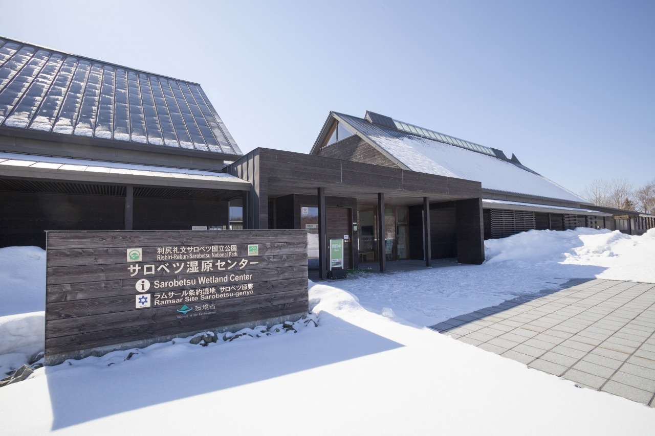
One of Japan’s largest wetlands, this vast 6,000-hectare expanse offers a quiet escape where land and sky seem to meet at the horizon.
Located in Toyotomi Town, Sarobetsu is Japan’s northernmost Ramsar-listed wetland. A 1-kilometer circular boardwalk begins at the Sarobetsu Wetland Center, making it easy to explore the heart of this unique environment. On clear days, the elegant silhouette of Mt. Rishiri rises in the distance, set against endless green plains.
As you walk, you’ll notice the gentle give of the peatland beneath your feet, along with the soft rustle of grasses and the calls of birds carried on the wind. This area was once a lagoon connected to the sea. Over thousands of years, layers of plant material gradually formed the wetland landscape seen today.
In early summer, the marsh comes alive with seasonal color. Ezo day lilies bloom in bright yellow, while cotton grass sways like white tufts across the fields. A light, earthy scent drifts through the air as you explore.After your stroll, visit the rest house to savor local specialties made with famous Toyotomi milk. It is the perfect place to surrender your senses to the profound silence and powerful vitality of Hokkaido’s untamed nature.
- Address
- 天塩郡豊富町上サロベツ8662
- Telephone Number
- 0162-82-3232
- Open
- 9:00-17:00 (10:00-16:00 from Nov. to Apr., 8:30-17:30 from Jun. and Jul.)
- Closed
- Mondays, December 29–January 3 (Open daily from May to October)
Cape Soya
Standing at the Northernmost Edge of Japan
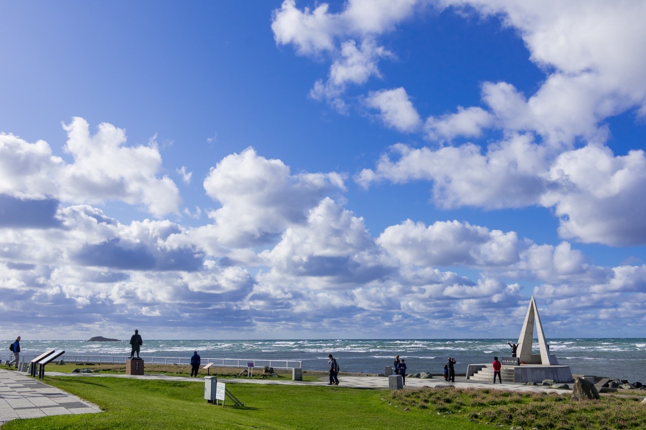
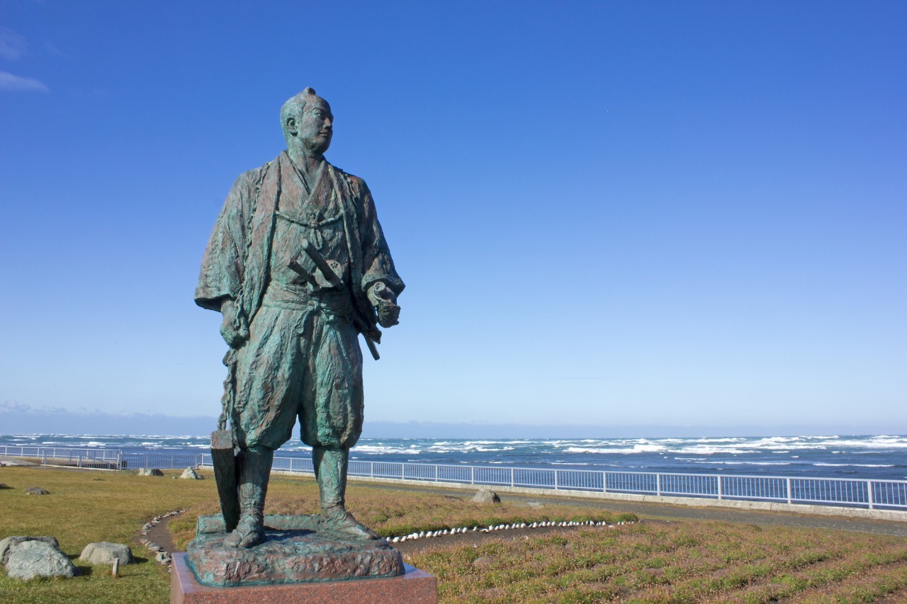
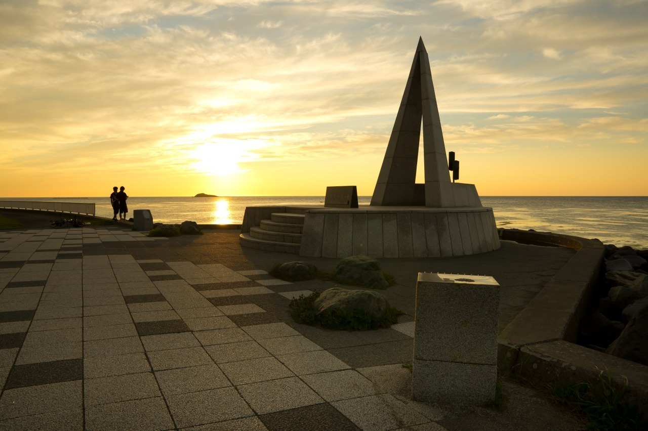
Gaze toward the horizon of Sakhalin from 45°31'22" North.
Cape Soya marks the northernmost point of Hokkaido, at 45°31'22" North. Known as Japan’s "Northern Terminus," it draws travelers with its dramatic location at the edge of the archipelago.
The vast, deep blue of the Sea of Okhotsk stretches before you. At the tip of the cape, the brisk northern wind and crisp air fill your senses. On clear days, when the horizon stretches out without a single obstruction, the silhouette of Sakhalin appears vividly about 40km away. It’s a moment when you truly realize you’ve reached the very edge of Japan.
In the center of the cape stands the "Monument of the Northernmost Point of Japan," an iconic triangular structure inspired by a single ray of the North Star. Nearby, the statue of Rinzo Mamiya—the famed explorer who once crossed over to Sakhalin—stands tall, gazing straight out at the sea. As you listen to the crashing waves and reflect on the journeys of pioneers who ventured into the unknown, the landscape takes on a deeper, more storied meaning. Cape Soya is a unique spot where the edge of Japan meets the endless sea and sky.
≪How to Get to Cape Soya by Route Bus≫ Soya Bus Official Website (Japanese)
- Address
- 稚内市宗谷岬
- Telephone Number
- 0162-23-6468
White Path, Soya Hills
A Scallop-Shell Road Leading to the Azure Sea
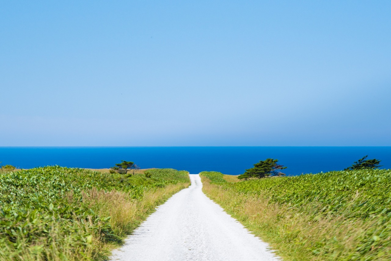
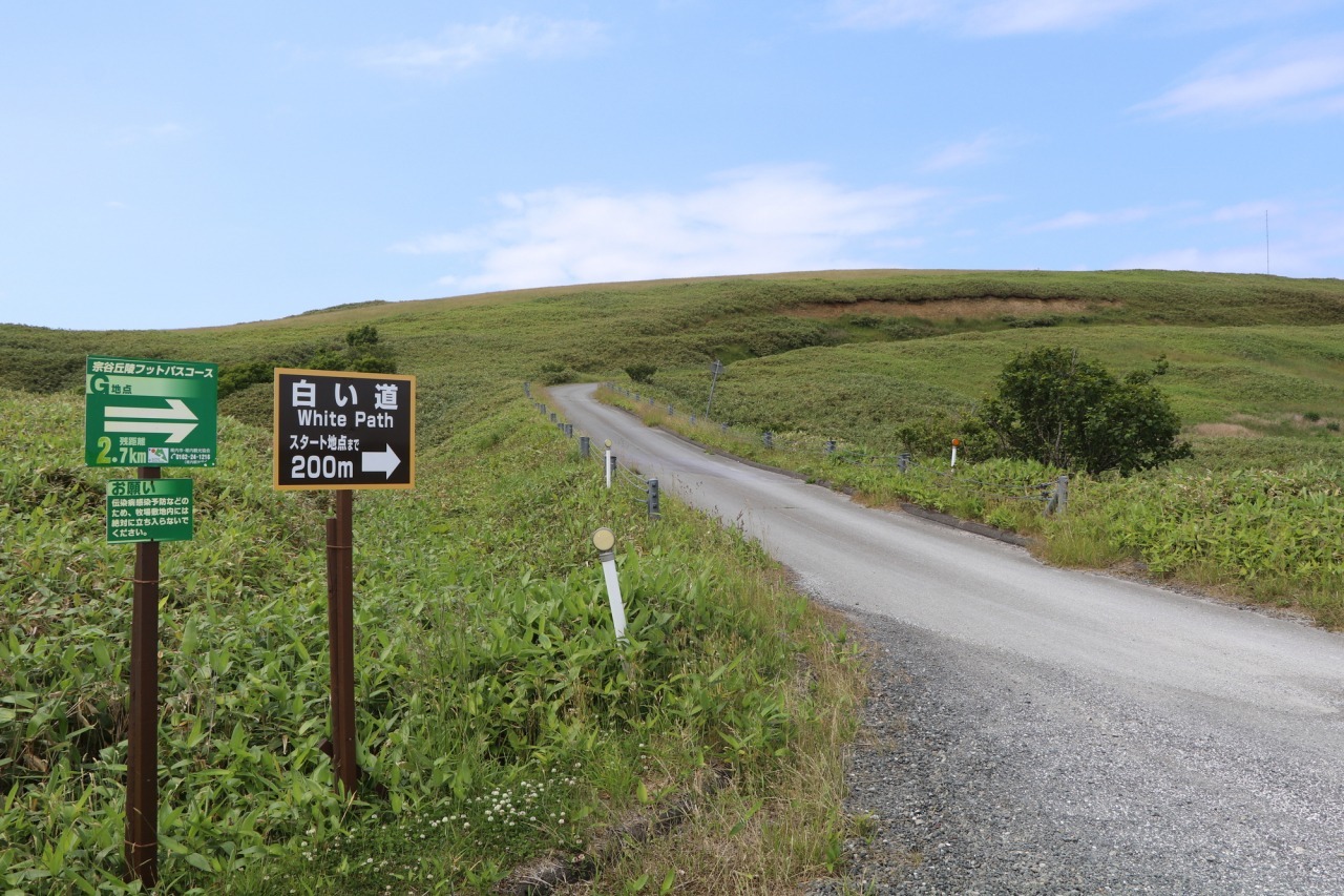
Walk along a 3km trail paved entirely with crushed scallop shells, where lush green hills meet the deep blue ocean.
The White Path is a trail made from Wakkanai’s famous scallop shells, offering a landscape unlike any other. As you walk, the finely crushed shells provide a soft, cushioned feel beneath your feet, accompanied by a satisfying rhythmic crunch. The refreshing sea breeze carries a faint scent of salt and seaweed, letting you fully immerse yourself in Japan’s northern frontier.
On clear days, the horizon reveals the majestic Mt. Rishiri and, far across the Sea of Okhotsk, the distant silhouette of Sakhalin. The hills are dotted with 57 giant wind turbines, standing as silent sentinels along the white trail, creating a scene that feels cinematic in scale.
The White Path is part of the “Wakkanai Footpath” course and is ideal for walking or cycling. Whether on foot or by bike, this living piece of art invites you to experience the perfect harmony of nature’s colors, sounds, and textures.
Note: The trail is pedestrian-friendly; cyclists and drivers should take care.
- Address
- 稚内市大字宗谷村字宗谷
- Telephone Number
- 0162-23-6468
- Closed
- Closed from mid-November to late April
Wakkanai Port North Breakwater Dome
An Ancient-Style Corridor at Japan’s Northern Edge
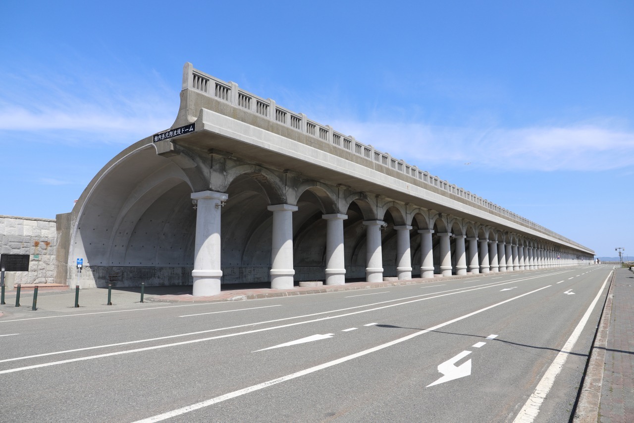
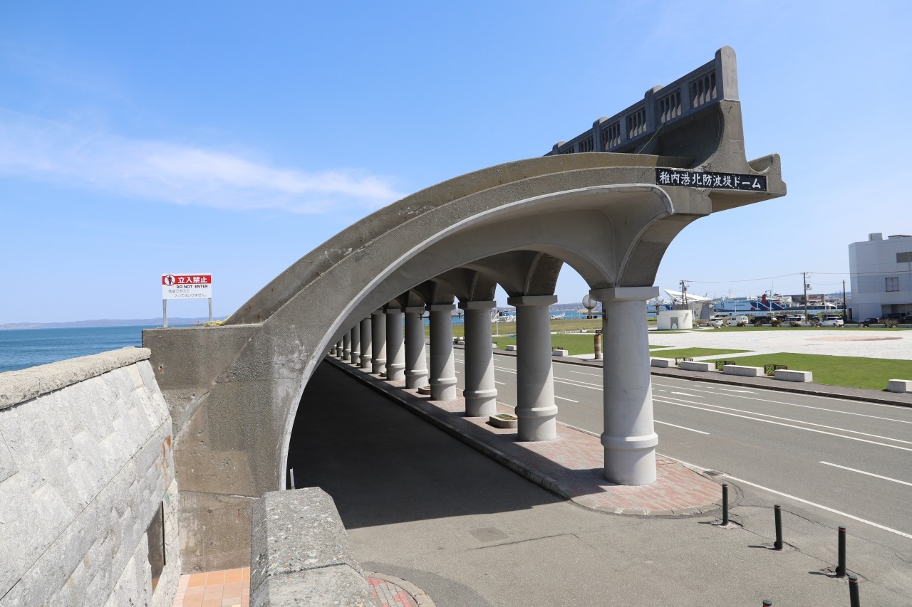
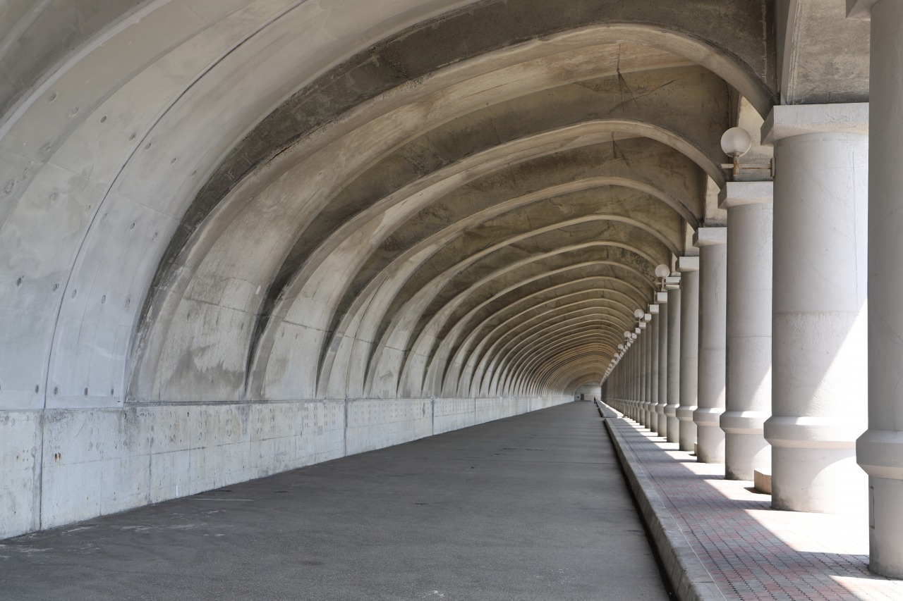
Walk through a 427-meter corridor of 70 soaring pillars—a Hokkaido Heritage site where history meets the sea.
Rising majestically along the shoreline of Wakkanai, the North Breakwater Dome stands firm against the fierce northern tides. This semi-arched structure, with its massive Roman-style columns, creates a breathtaking sight unlike any other in the world.
The dome reaches 14 meters in height and took five years to complete. Originally built as a sheltered walkway connecting the harbor to the railway station, it protected travelers from the harsh northern winds. Today, its elegant curves evoke the grandeur of an ancient Greek temple, offering a one-of-a-kind spectacle that has captivated visitors for decades.
Step inside, and feel the cool touch of concrete and hear the resonant echoes of the wind whistling between the pillars. Imagine the travelers of the past, their hearts full of anticipation for journeys to Sakhalin. Now a designated Hokkaido Heritage site, the dome’s photogenic scenery makes it a popular filming location for movies and commercials.
Experience a serene space where history and modern life intersect, all while enjoying the crisp sea breeze unique to Wakkanai.
- Address
- 稚内市開運
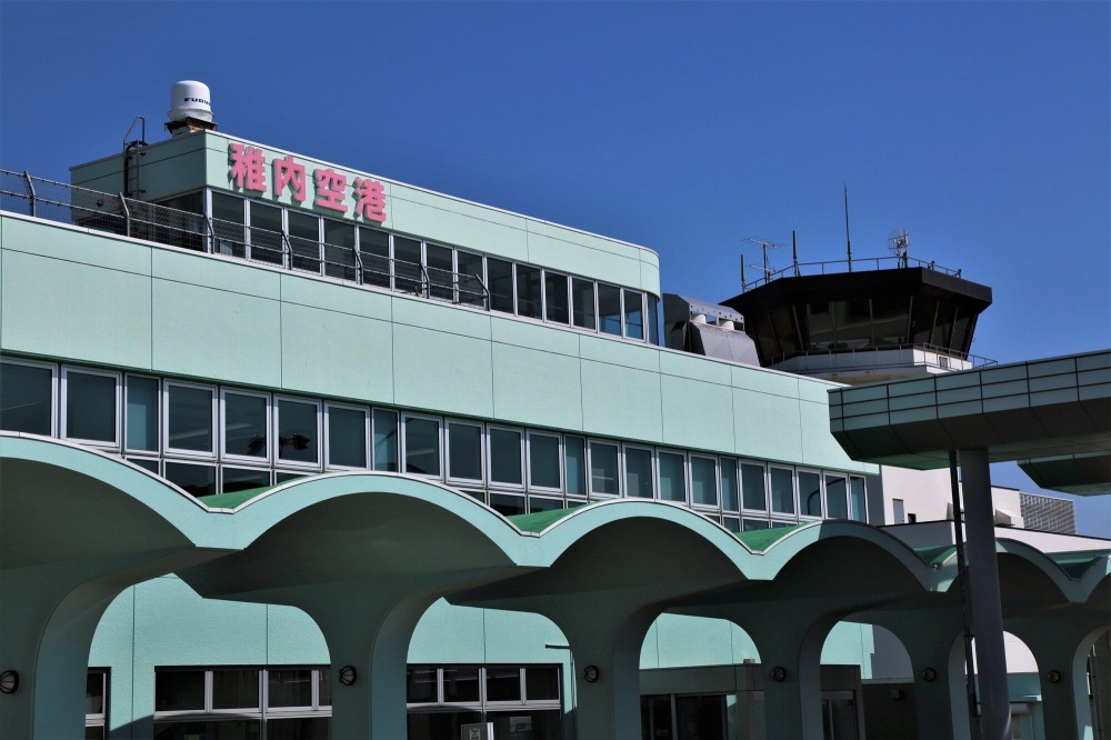
Wakkanai Airport
How was your off-the-beaten-path trip to Northern Hokkaido, filled with sunsets, hot springs, and delicious food? We hope the time you spent in Japan's northernmost region was a truly unforgettable experience that has been deeply etched into your heart.
![[New Chitose Airport IN → Obihiro Airport OUT / 2 Nights 3 Days] Ancient Fossils, Horse Culture, Genghis Khan, Moor Hot Springs... A Hokkaido Heritage Trip to Enjoy Various Attractions](/lsc/upfile/course/0000/0092/92_1_m.jpg)
![[New Chitose Airport IN & OUT / 3 Nights 4 Days] Climb Mikuni Pass by E-Bike, Cross Lake Shikaribetsu by Kayak! An Active Adult Trip to Savor Breathtaking Scenery](/lsc/upfile/course/0000/0089/89_1_m.jpg)
![[New Chitose Airport IN & OUT / 3 Nights 4 Days] Experience Toya-Usu UNESCO Global Geopark! A Trip to Feel the Coexistence with Volcanoes and the](/lsc/upfile/course/0000/0088/88_1_m.jpg)
![[New Chitose Airport IN & OUT / 3 Nights 4 Days] Canoe Experience at Lake Shikotsu, Ainu Culture Experience in Biratori Town! An Adventure Travel Course to Stimulate Intellectual Curiosity](/lsc/upfile/course/0000/0087/87_1_m.jpg)
![[Sapporo Station IN & OUT / 3 Nights 4 Days] SUP in the Sea, E-MTB in the Forest, Otaru Canal and Horserogue Too! A Course Full of Experiences in Shakotan, Otaru, and Sapporo](/lsc/upfile/course/0000/0086/86_1_m.jpg)
![[New Chitose Airport IN → Wakkanai Airport OUT / 3 Nights 4 Days] Rishiri Island Cycling, Rebun Island Trekking, White Road Cycling - The Northernmost Active Trip](/lsc/upfile/course/0000/0085/85_1_m.jpg)
![[Asahikawa Airport IN → Obihiro Airport OUT / 2 Nights 3 Days] Conquer All 7 Spots of the Popular Hokkaido Garden Highway! A Trip to Heal Your Heart with Beautiful Scenery and Hot Springs](/lsc/upfile/course/0000/0084/84_1_m.jpg)
![[New Chitose Airport IN & OUT / 3 Nights 4 Days] Lake Toya, Upopoy, and Dolphin Watching! A Trip to Enjoy Surrounding Sights Based at Noboribetsu Karurusu Onsen](/lsc/upfile/course/0000/0083/83_1_m.jpg)
![[Memanbetsu Airport IN → Kushiro Airport OUT / 1 Night 2 Days] After Enjoying Forest Bathing and Walking, Stay at a Lamp-Lit Inn! A Casual Weekend Refresh Trip](/lsc/upfile/course/0000/0082/82_1_m.jpg)